Airspace infringement maps
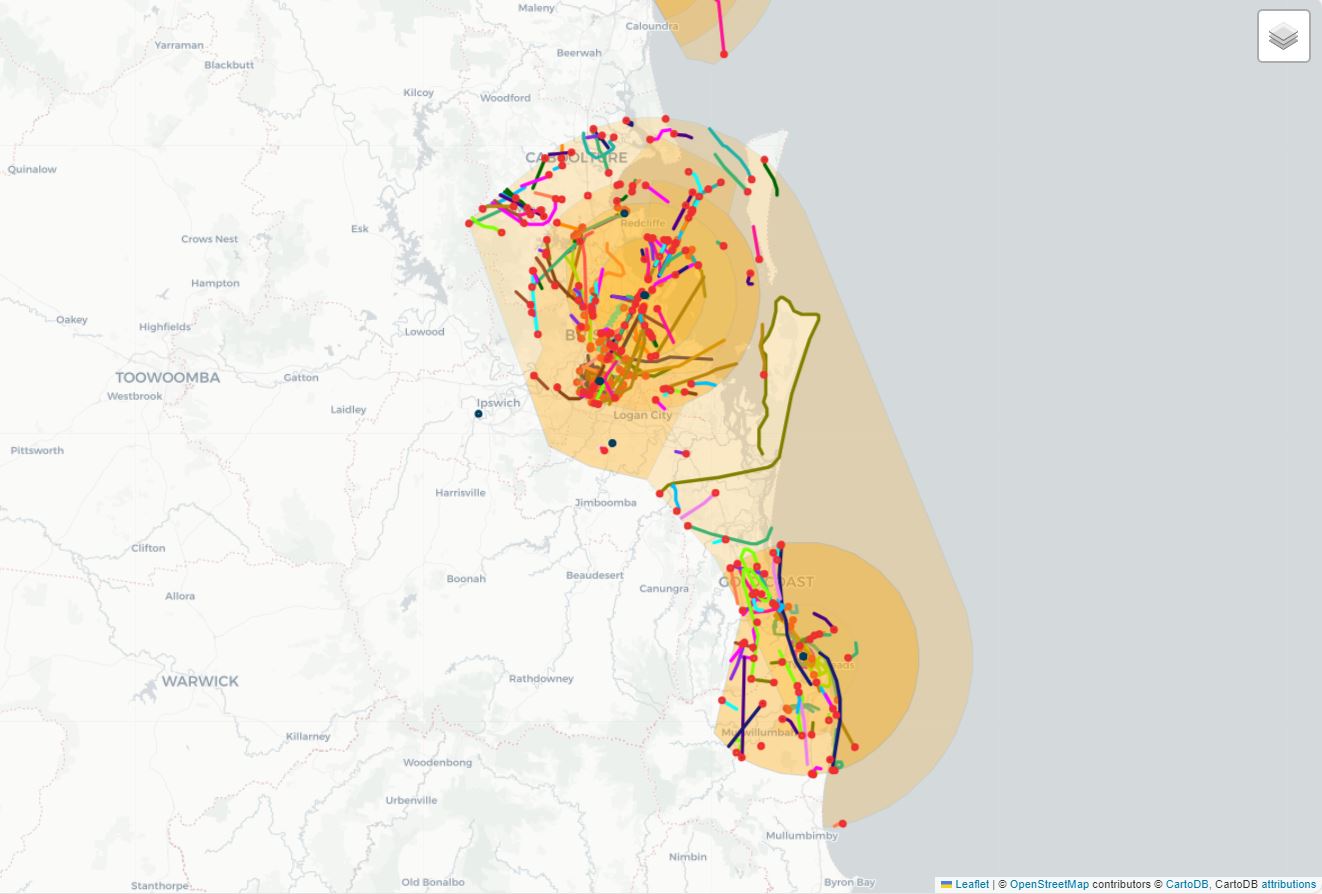
We have plotted every Airspace Infringement (AI) in controlled or restricted airspaces between 1 January 2021 and 30 June 2024 based on available data. An AI is counted as every time a flight infringes an airspace volume, so one flight may result in multiple AIs. See maps below. Users may filter through airspaces by clicking on the stack of tiles in the upper right-hand corner of each map and selecting or de-selecting layers. Airspaces are sorted by their upper airspace flight level (‘upper FL’). In the case of controlled airspace volumes, they are coloured according to their service level (‘A’ corresponds to red, ‘C’ orange, ‘D’ green, and ‘E’ blue).
Infringements associated with drones (RPAS) are excluded.
For most infringements, we have identified an infringed airspace and infringing flight. We marked these infringements with a red circle at the point the flight entered the infringed airspace – and we have plotted the flight’s trajectory for as long as it was in the infringed airspace. Clicking on an area will reveal an airspace’s name, and clicking on a trajectory or an entry point will reveal the timestamp and infringed airspace associated with an Airspace Infringement.
Explore the airspace infringement maps
Controlled airspaces
Map 1 shows every Airspace Infringement in controlled airspace. Infringements with insufficient data are presented with blue circles.
Map 2 shows every controlled Airspace Infringements in which the infringing aircraft moved laterally into the airspace volume.
Map 3 shows every controlled Airspace Infringement in which the infringing aircraft moved vertically into the airspace volume.
Restricted airspaces
Map 4 shows every Airspace Infringement in restricted airspace. Infringements with insufficient data are presented with blue circles.
Map 5 shows every restricted Airspace Infringement in which the infringing aircraft moved laterally into the airspace volume.
Map 6 shows every restricted Airspace Infringement in which the infringing aircraft moved vertically into the airspace volume.
Data limitations
Data limitations
Though we have tried to plot each Airspace Infringement, sometimes we specify the incorrect infringing airspace and/or infringing flight. This may be due to one or more of four limitations:
- AI geographic locations may be incorrect due to imprecision in reporting.
- AI flight levels may be incomplete due to imprecision in reporting.
- AI occurrence timestamps may be estimated.
- Airspace flight level restrictions may be associated with different hours of the day – or may be imposed at the discretion of air traffic management. Our analysis treats these restrictions as static.

Though we canvas a wide area – and a range of times – around each infringement to find the likeliest candidates, we may nonetheless focus on the incorrect airspace volume and/or flight.

Avoiding airspace infringements
Equip yourself for a safer flight with knowledge of the current issues contributing to airspace infringement in your airspace. Learn current threats, errors, and countermeasures related to airspace infringement, as well as lessons learned from past occurrences.
Related links
- Aviation Resources for Pilots | CASA
- Aviation Weather Services | BoM
- Latest Investigations & Reports | ATSB
- SKYbrary| Eurocontrol, ICAO, Flight Safety Foundation
- Stay onTrack Series | CASA
Further reading
- ATC Notes – Understanding airspace infringements | Flight Safety Australia | Airservices Australia
- Hindsight 11 - Airspace Infringement: sudden & unexpected | Eurocontrol
- Why airspace infringements have the potential to impact all of us | NATS
- Airspace Infringement Series: A controllers story… | NATS
Videos & podcasts
- Controlled aerodromes and operations - Avoiding airspace infringements | CASA and Airservices Australia
- Avoiding airspace infringement | EASA
- Human factors for pilots – Introduction | CASA
- Human factors for pilots – Communication | CASA
- AVSafety podcast – Ep3 – Pilot safety: Why flight planning is critical | CASA