WebTrak allows you to see where aircraft fly and explore historical trends and patterns.
WebTrak uses information from air traffic control secondary surveillance radars to display aircraft movements:
- within 100 kilometres of the major airport
- up to 30 000 feet above mean sea level
Aircraft noise data is also displayed, collected daily from noise monitors strategically located around communities close to the airport.
WebTrak is available for the following areas:
Frequently Asked Questions
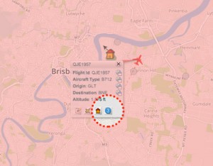
The flight search and display function allows you to view aircraft flight activity over metropolitan areas. You can also:
- locate your street address and have your home appear on the map
- see noise levels of individual aircraft
- view information about aircraft type, height, origin and destination
- display an aircraft’s flight path and point of closest approach to your home
- zoom in and out down to street level.
Note that there is a 3-minute delay on display of flights.
When you enter WebTrak you will arrive on the flight search and display screen. Select Help from the menu in the top left-hand corner for instructions.
To access a Text Only version of WebTrak, go to the Accessibility tab of the Help menu or access Text Only WebTrak directly.
WebTrak data for the major airports is checked overnight. Before data is checked there are more likely to be gaps or inaccuracies in the display. Therefore it is more accurate the following day. More information about technical issues including data accuracy is available in the Terms of Use and Notices that you accept when you enter the site and in the About tab of the Help menu. Additional information can be found under Technical information below.
Unlike WebTrak data for major airports, the data for secondary airports such as Jandakot, Parafield, Moorabbin, Bankstown and Archerfield is not "groomed" and is therefore subject to many more inaccuracies. Therefore, displays of movements at and around these airports should not be relied upon.
Some aircraft are routinely excluded from WebTrak for security and operational reasons. This may include emergency services aircraft (Police, Fire, Rescue & Ambulance), military, intelligence agencies, government officials, aircraft involved in incidents and other aircraft.
Note: not currently available for Sunshine Coast.
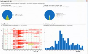
WebTrak provides an overview of where aircraft typically fly, providing an understanding of operations and patterns over time. Common flight paths are shown as ‘swathes’. You can see how often a particular flight path is used on a monthly, quarterly or annual basis, by time of day or weekday/weekend.
You can also look at data from noise monitors over these periods.
This information will help you gain a better understanding of aircraft operations and noise in your area. It will also allow you to find out whether the aircraft operation is typical or not, which suburbs are overflown more frequently than others and the seasonal variations for flight paths.
There are two ways to access the historical trend information:
- go to the Quick Start Guide in the top left-hand corner of the WebTrak screen, and click the “Historical” link
- after double-clicking an aircraft on the flight search and display screen, select the blue information icon in the flight information box - this will display the aircraft's track as well as the historical information
Learn more in our Guide to accessing historical trend information from WebTrak
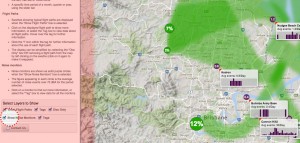
Flight path ‘swathes’ (in green) show typical flight paths when the show flight paths box is selected. You can remove swathes by double clicking on the swathes you want to remove. You can get these back at any time by clicking on the light grey area.
Further information can also be found by clicking on the circle or selecting the tag box.
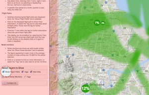
‘Swathes’ can be tailored to reflect weekday or weekends and day, evening or night operations.
A specific time period of a month, quarter or year can also be selected using the slider at the bottom. Scroll this left and right to select the time period you are interested in.
![]()
Information is available on how many flights and what type of aircraft use flight paths by selecting the information symbol in the swathe information box.
']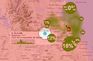
You can also see the percentage of flights that use the flight path selected compared to other paths.
Noise monitors are shown when the show noise monitors box is selected.
When the noise level exceeds a pre-set threshold level the monitor will start recording and saving the noise data.
If an aircraft appears to pass close to a monitor but does not display a noise reading, this may be due to a range of factors:
- the noise data has not yet been downloaded from the monitor (try again in 24 hours)
- the aircraft passed the monitor at a high altitude
- severe weather conditions (such as high wind) reduced the aircraft noise at the monitor below the threshold
- the monitor could be offline for upgrades or maintenance during the over-flight (as the monitors are exposed to the weather, regular maintenance is required to keep them accurate).
The figure that appears in the purple circle are the number of noise events over 70dB(A) for the period selected.
You can also find out more information on aircraft noise by hovering over the graph.
WebTrak is provided by Envirosuite, formerly EMS Brüel & Kjær
Some aircraft are routinely excluded from WebTrak for security and operational reasons. This may include emergency services aircraft (Police, Fire, Rescue & Ambulance), military, intelligence agencies, government officials, aircraft involved in incidents and other aircraft.
Data validation and accuracy
Data for major airports captured by WebTrak undergoes a daily checking process by Envirosuite. This means that data in replay mode (the day after) will be more accurate than in current flight mode.
WebTrak data for secondary airports such as Jandakot, Parafield, Moorabbin, Bankstown and Archerfield is not "groomed" and is therefore subject to many more inaccuracies. Therefore, displays of movements at and around these airports should not be relied upon.
For movements to and from major airports, the lateral accuracy (where an aircraft is over the ground) of WebTrak is dependent on the radar information the system uses. Radar can be inaccurate by small distances, depending on the aircraft's distance from the radar and the type of aircraft movement. Airservices performance criteria for radar include thresholds for margins of error (tolerances).
WebTrak ‘smooths’ readings from individual radar points to show a consistent track. For scheduled flights which perform smooth turns, the lateral accuracy is better than 250 metres at 40 kilometres from the radar site. For aircraft that make tight turns (for example, aerobatic aircraft or helicopters), the lateral accuracy is 450 metres at 40 kilometres from the radar site. This means that aircraft may not have flown exactly on the track shown on WebTrak.
Height information is derived from changes in air pressure recorded by aircraft in flight. This is corrected for pressure variations at the ground during the flight. The margin of error using this method is 125 feet—so that at any one point, the aircraft may have been 125 ft higher or lower than the altitude shown on WebTrak. However, extreme weather conditions that cause rapid changes in pressure, such as the approach of a cold front, can further affect the accuracy of aircraft height measurements.
In extreme cases, WebTrak can give the impression that an aircraft has deviated off the runway. This is due to radar reflections that can occur at low altitudes.
Liability and copyright
Envirosuite have made every reasonable effort to ensure the information presented is accurate. However, the data within WebTrak may still contain inaccuracies in some cases. It should not be relied upon when making personal, legal or financial decisions.
WebTrak is provided for personal and non-commercial use. Users may not modify, copy, distribute or reproduce in any form the data obtained from WebTrak. All maps used by WebTrak are copyright. For further information, contact Envirosuite.
Privacy and personal information
Refer to the Terms of Use and Notices which you accept when you access WebTrak. These are also available via the About tab of the Help menu in WebTrak.